I think this is a great indicator of where we are heading with the Internet of Things. Cars are carrying technology that will eventually have static locations in great numbers. Veniam have created a mesh network for providing WiFi to cities, and is deployed to public transportation. Obviously hundreds more nodes that are fixed is a better solution, but it is more difficult to get going.
Likewise Aclima has teamed up with Google Street View vehicles to monitor the air quality of many locations:
In the first pilot, three Street View cars collected 150 million air quality data points over a month of driving around Denver, Colo. They measured for chemicals that are hazardous to breathe, like nitrogen dioxide, nitric oxide, ozone, carbon monoxide, carbon dioxide, methane, black carbon, particulate matter, and Volatile Organic Compounds (VOCs).
Again, having these sensors in fixed locations would provide superior and constant data – it will just cost substantially more to deploy, and will require the co-operation of local governments.
If this entry-point for trialling Things becomes commonplace, it will need a name. As this is the first place online to mention these two companies in the same breath, I guess I should give it a go… It could be CarStrapping, SwarmTest or Mobeta.
Perhaps in a few years there will be a company that sends cars loaded with Thing sensors around cities to test them?
—
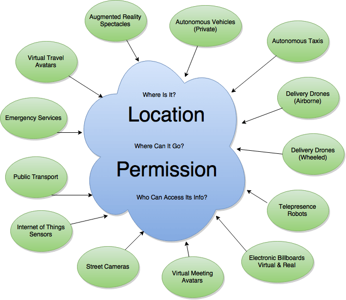
Yet I maintain that the end goal will be static sensors. This means co-operation with local government, which suggests a big role for authorities in the future of mapping. I can imagine a Municipal Operating System that combines IoT Sensors, autonomous taxis, emergency services, and much more.